
Notes on the history of Little Thetford
Compiled by Pat and Mike Petty : February 1981, revised May 2009
Contents
Page 1: Introduction
Page 2: Early settlement and Place names
Page 3: Buildings and infrastructure
Page 4: Newspaper clippings: 1778 – 1799
Page 5: Newspaper clippings: 1801 -1899
Page 6: Newspaper clippings: 1900 -1940
Page 7: Ely Deanery Magazine Extracts: 1895 -1896
Page 8: Village people: 19th & early 20th century
Early Settlement
| One of the earliest references to a settlement at this present place is in a charter of 972 when the name was spelt ‘thiutforda’. This is a combination of ‘thiut’ meaning people or nation and ‘forda’ meaning ford. Just across the river is a farm called ‘Fordey’ meaning ‘low lying land by a ford’. It would seem logical therefore that somewhere in the area was the site of a river crossing.In 1932 a Barway farmer observed wooden pile in two of his ditches. Frequently whilst ploughing he found that tops of posts were snagging the plough. So he set to work to remove the offending objects and unearthed a forest of great stakes which were embedded in the clay. When these stakes were stood up in their holes he could see a causeway stretching out towards Little Thetford.
Could this perhaps have been where William the Conqueror made his invasion of the Isle of Ely against its defender Hereward the Wake, for the records of the time speak of ‘an innumerable people carrying brushwood and sand in sacks in order to make a causeway across the river to take the fortification?’ Archaeologists set out to try and discover the truth. They soon discovered the causeway and found that it was largely composed of decayed brushwood kept in place by the occasional beams and stakes with above it a layer of fine sand. But then they found something else, a piece of pottery in the brushwood itself which was far older than Norman times. A little further away was found a bronze ring and yet more pottery. All this cannot have been from the time of William the Conqueror, it was older than the Romans. The chances are high that in fact it was Bronze Age, that this was an age old crossing place of the Great Ouse River, a major highway, a ‘national road’ which gave ‘Thetford’ its name. Extracted from ‘Investigation of the ancient causeway in the fen between Fordy and Lt. Thetford’ by T. C. Lethbridge, published in Cambridge Antiquarian Society ‘Proceedings’ vol.33: 1933 |
|
Place Names |
|
Extracts from the Place-Names of Cambridgeshire and The Isle of Ely by P. H. Reaney. 1943
Of the two local farms it states:
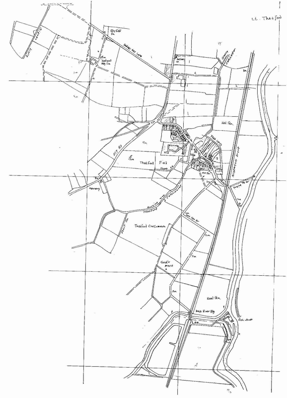
(Mike Young’s map prepared from air photographs) In 1953 Mr.R.E. Kisby wrote this account of the growth of Little Thetford in the ‘Growing Areas Year Book’ The siting of many of our villages was determined more often by the river than a (then non-existent) hard road. For a good example of this take the small village of Little Thetford (Thet-ford, peoples-ford). The older part of Thetford and its older house, the mill and a (now demolished) Church were on the edge of high ground, near the river and their eyes turned riverwards. Large amounts of broken pottery were found near the river and this indeed was their exit and traffic thoroughfare. The turnpike road to Ely did not exist but wandered over the higher ground probably at a different place from the present road. A track to Ely existed but by our standards it was a drove and they were cut off from the outside world with at the back door nothing but a dreary track, whereas the river was the broad highway used for the transport of goods. The passage of important personages by river would also be witnessed between Ely and Cambridge and further a field than this. What significant change has occurred in Thetford village? Gradually the building of houses has crept towards the current line of communication. This movement was halted in the 19th century by the focus of interest in the village school and the hub of the village became centred in a tiny square consisting roughly of the school, three pubs (then existing), and the Church. But the halt was short lived and movement has increased rapidly with the council houses built in the past twenty years: a movement that is just short of ribbon building along the main Ely Road. The school is no longer a focal point and there is only one pub. We know that where the Feoffees Almshouse now stands at one time there was a building known as Guildhall, but what purpose this served we do not know. Of the passing traffic by water on the Ouse, Daniel Defoe wrote in 1722 of Stourbridge Fair in Cambridge only 14 miles distant: ‘I must not omit here also to mention that the river Grant, or Cam, which runs close by the North West side of the fair on its way from Cambridge to Ely, is navigable, and that by this means all heavy goods are brought even to the fair-field, by water carriage from London and other parts; first to the port of Lynn, and then in barges up the Ouse into the Cam, and so, as I say, to the very edge of the fair.’ Extracts from The Victoria County History of Cambridgeshire and the Isle of Ely, Vol.4., 1953. The professional historians of London University Institute of Historical Research say the name Theod-ford, ‘ford of the nation’ (road), suggests that the main road into Ely may at one time have followed the lower ground past Braham Farm and into the city by Cawdle Fen Drove and Potters Lane to the Waterside, the medieval focal point of Ely. An area of 233 acres was transferred from Ely Urban District to Thetford under the Isle of Ely Review Order 1933, thus increasing the population by 29. |
|
|
—
Pat and Mike Petty, February, 1981.
Postscript
These notes were compiled 28 years ago and since then much more information has become accessible. None of this has been included in this reissue of the original pamphlet.
See my website www.cambridgeshirehistory.com/MikePetty for advice and guidance
Mike Petty, June 2009.
Recent Comments